J. Oberling, R. Crouch, T. Guidry
Since the last update we have tried a couple of things.
First, we attempted to align the FARO to the BSC2 chamber directly. We placed the FARO in the biergarten and shot the chamber-side door flanges. We used the SMR to sweep along the outside of the +X side of the +Y door flange, and the +Y side of the +X door flange. The shots were done as circles, which we could then place a point at circle center to represent the center of the door flange. The hope was we could then project lines to represent the X and Y axes, and use that to align to our origin using a Plane/Axis/Center Point alignment routine. I won't go into much detail, as it didn't work. We used this alignment to look at PSI-6 in the biergarten, and it was off by over 1cm; we then looked at LV-35 and that one was off by even more. I don't remember exact values as we didn't save screenshots since the devaiations were so large. Let's say that if these deviations were true, I'm not sure how we would have a functioning, aligned, and alignable IFO. So, that experiment didn't work, moving on.
Today we decided to try using height marks 901, 902, and 903 to set our Z axis alignment. We looked at marks 901 and 902 with an autolevel and compared them to our BSC2 door flange scribe average we had used the water tube level to measure (alog 75974) and the listed local Z coordinate from T1100187. Results:
- 901:
- T1100187: -54.7 mm
- Water level: -55.2 mm
- Difference: -0.5 mm
- 902:
- T1100187: -62.7 mm
- Water level: -62.9 mm
- Difference: -0.2 mm
Not bad, and definitely not the almost +4mm the FARO was measuring for these marks w.r.t. BTVE-1. If we use our differential height survey from alog 75771 we can also calculate the local Z axis coordinate for mark 903, which comes out to -79.8 mm (versus the listed coordinate of -79.9 mm from T1100187), and again not the almost +4mm reported by the FARO when measured w.r.t. BTVE-1. It's looking more and more like there was some error in the Z axis position of BTVE-1; whether that error was in setting the monument itself or in setting BSC2 w.r.t. to BTVE-1 we cannot say. The fact of the matter is that when compared to BSC2 as it sits right now based on our water level survey, the height marks we've looked at are pretty close to their listed coordinates and BTVE-1 is definitely not. We also happened to do the same differential height survey with BTVE-1 (also in alog 75771), so we can calculate a local Z coordinate for BTVE-1 based on our height mark 903 (which we have now tied to BSC2 Z=0). Doing so gives a local Z axis coordinate for BTVE-1 of -1060.3 mm (Z903 - deltaZBTVE-1/903 = -79.8 - 980.5); this becomes -1060.9 mm once we convert to our global coordinate frame (which is decidedly not the -1057.2 mm all of the old documentation lists it as).
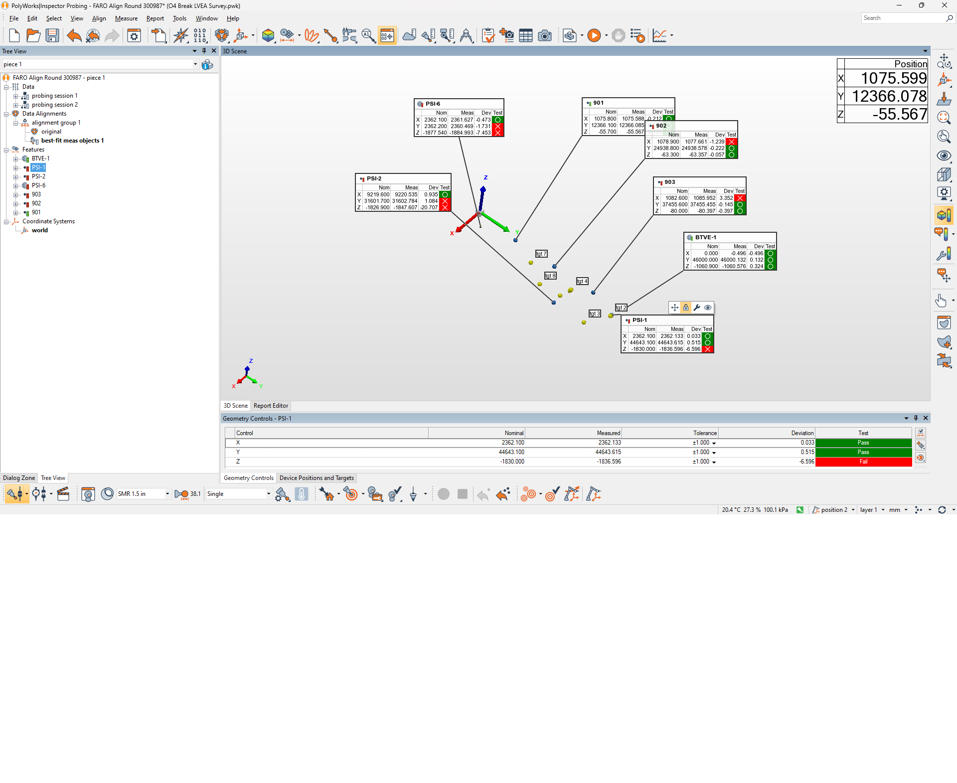
Now that we have local Z coordinates for 901, 902, 903, and BTVE-1 that have all been tied to BSC2 Z=0, we used these to set a new alignment. First, we need global Z coordiantes for our 3 height marks. We got these by using a autolevel to set a magnetic nest inline with the height mark to be measured. The FARO was put into an intial alignment using BTVE-1, PSI-1, PSI-2, and PSI-6 (X and Y are generally pretty good, Z is off but we don't care yet), and we then placed the SMR on the nest we placed inline with 903. From this we got an X/Y coordinate for the nest that we could use to calculate our global Z. Once this was done we added 903 into the alignment routine, and removed PSI-1, PSI-2, and PSI-6 for the Z axis fit. we then moved the FARO to a position where we could see 901 and 902 and shot them in the same way we did 903. Ultimately, we ended up with an alignment using BTVE-1, PSI-1, PSI-2, and PSI-6 for X and Y and 901, 902. and 903 for Z. The coordinates used for the height marks were (format is [X,Y,Z]):
- 901: [1075.8, 12366.1, -55.7] mm
- 902: [1078.9, 24938.8, -63.3] mm
- 903: [1082.6, 37455.6, -80.0] mm
Tyler has a screenshot of the results of the alignment that he'll post as a comment to this alog. One thing to note here: We were not using the new BTVE-1 Z as part of the Z axis alignment, only marks 901, 902, and 903. It's somewhat comforting to see the Z axis coordinate of BTVE-1 as calculated by the alignment routine as close as it is to what we think the nominal shoud be based on our water level survey of BSC2. The PSI monuments are all out, especially PSI-2. I'm not sure how concerning this is, as we don't trust the Z coordinates of the PSI monuments anyway.
One caveat here, all of the height marks we used are almost in a line down the Y axis, with very little deviation in the X axis coordinate (a deltaX of less than 7mm across ~25m of the Y axis). I'm not entirely confident we're picking up the global tilt of our X axis with this configuration. We want to take this alignment and test and refine it; first thing we can do is get some more height marks spread along the X axis to hopefully catch the global X axis tilt. More to come!